{
"uuid": "005b7495-c41f-4bf8-aa48-e71d308ac579",
"type": "records",
"etag": "95fe94277c6148259dc3e86c242413d564126d22",
"data": {
"dc:language": "en",
"dwc:latestPeriodOrHighestSystem": "Cretaceous",
"dc:type": "PhysicalObject",
"dwc:recordedBy": "Johnson, J",
"dwc:georeferencedDate": "2021-05-01",
"dwc:georeferenceRemarks": "This locality is in CO, not NM. Late Cretacous Cliff House ss, Menefee Fm, and Mancos Shale occur here.",
"dwc:occurrenceID": "9d2405a9-090f-11e3-af8d-50faf7e7a06b",
"id": "9d2405a9-090f-11e3-af8d-50faf7e7a06b",
"dwc:stateProvince": "Colorado",
"dwc:institutionCode": "UCM",
"dwc:country": "United States",
"dwc:earliestPeriodOrLowestSystem": "Cretaceous",
"dwc:collectionCode": "IP",
"dwc:county": "Montezuma",
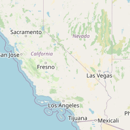
"dwc:decimalLatitude": "37.263408",
"dwc:locationID": "5 mi. S. of Cortez, NM",
"dwc:basisOfRecord": "FossilSpecimen",
"dwc:continent": "North America",
"dwc:latestEpochOrHighestSeries": "Late Cretaceous",
"dwc:eventID": "2018049",
"dwc:georeferenceSources": "GeoLocate; https://ngmdb.usgs.gov/Prodesc/proddesc_68589.htm",
"dwc:institutionID": "UCM",
"dwc:geodeticDatum": "WGS84",
"dwc:formation": "CliffHouse, Menefee, and Mancos",
"dwc:catalogNumber": "17163",
"dwc:decimalLongitude": "-108.582493",
"dwc:coordinateUncertaintyInMeters": "1983.0",
"dwc:georeferencedBy": "Finlayson, Heather",
"dwc:earliestEpochOrLowestSeries": "Late Cretaceous",
"dwc:georeferenceProtocol": "Georeferencing Quick Reference Guide Version 2012-10-02",
"dwc:class": "Bivalvia",
"dwc:genus": "Cucullaea",
"dwc:phylum": "Mollusca",
"dwc:taxonRank": "Species",
"dwc:kingdom": "Animalia",
"dwc:family": "Cucullaeidae",
"dwc:scientificName": "Cucullaea terminalis",
"dwc:specificEpithet": "terminalis",
"dwc:order": "Arcoida"
},
"indexTerms": {
"recordset": "d621e959-2633-4ec1-a2a2-5d97cd818b47",
"dqs": 0.30434782608695654,
"stateprovince": "colorado",
"earliestepochorlowestseries": "late cretaceous",
"county": "montezuma",
"earliestperiodorlowestsystem": "cretaceous",
"catalognumber": "17163",
"latestperiodorhighestsystem": "cretaceous",
"continent": "north america",
"uuid": "005b7495-c41f-4bf8-aa48-e71d308ac579",
"countrycode": "usa",
"basisofrecord": "fossilspecimen",
"collector": "johnson, j",
"institutioncode": "ucm",
"datemodified": "2024-05-14T21:08:40.751119+00:00",
"etag": "95fe94277c6148259dc3e86c242413d564126d22",
"hasMedia": false,
"hasImage": false,
"indexData": {
"dc:language": "en",
"idigbio:dateModified": "2024-05-14T21:08:40.751119",
"dwc:latestPeriodOrHighestSystem": "Cretaceous",
"dc:type": "PhysicalObject",
"dwc:recordedBy": "Johnson, J",
"idigbio:uuid": "005b7495-c41f-4bf8-aa48-e71d308ac579",
"dwc:georeferencedDate": "2021-05-01",
"flag_gbif_reference_added": true,
"flag_dwc_scientificnameauthorship_added": true,
"idigbio:recordIds": [
"d621e959-2633-4ec1-a2a2-5d97cd818b47\\9d2405a9-090f-11e3-af8d-50faf7e7a06b"
],
"dwc:occurrenceID": "9d2405a9-090f-11e3-af8d-50faf7e7a06b",
"flag_dwc_taxonrank_replaced": true,
"dwc:decimalLatitude": "37.263408",
"flag_gbif_genericname_added": true,
"id": "9d2405a9-090f-11e3-af8d-50faf7e7a06b",
"flag_dwc_datasetid_added": true,
"idigbio:parent": "d621e959-2633-4ec1-a2a2-5d97cd818b47",
"dwc:stateProvince": "Colorado",
"flag_gbif_taxon_corrected": true,
"dwc:parentnameusageid": "2286188",
"dwc:country": "United States",
"dwc:earliestPeriodOrLowestSystem": "Cretaceous",
"dwc:multimedia": [
{
"dcterms:license": "creative commons attribution share alike 3.0 unported",
"dcterms:title": "view of umbones of cucullaea labiata (lightfoot, 1786)",
"dcterms:references": "http://commons.wikimedia.org/wiki/file:cucullaea_labiata_3.jpg",
"coreid": "2286188",
"dcterms:identifier": "http://upload.wikimedia.org/wikipedia/commons/e/e0/cucullaea_labiata_3.jpg",
"dcterms:source": "english wikipedia - species pages",
"dcterms:description": "english: cucullaeidae: cucullaea labiata (lightfoot, 1786)",
"dcterms:creator": "shellnut",
"dcterms:publisher": "wikimedia commons"
}
],
"idigbio:etag": "95fe94277c6148259dc3e86c242413d564126d22",
"dwc:collectionCode": "IP",
"flag_dwc_multimedia_added": true,
"flag_gbif_vernacularname_added": true,
"dwc:county": "Montezuma",
"dwc:georeferenceRemarks": "This locality is in CO, not NM. Late Cretacous Cliff House ss, Menefee Fm, and Mancos Shale occur here.",
"dwc:locationID": "5 mi. S. of Cortez, NM",
"dwc:basisOfRecord": "FossilSpecimen",
"dwc:taxonomicstatus": "accepted",
"dwc:continent": "North America",
"idigbio:isocountrycode": "usa",
"dwc:latestEpochOrHighestSeries": "Late Cretaceous",
"flag_dwc_taxonid_added": true,
"dwc:geodeticDatum": "WGS84",
"idigbio:siblings": {},
"flag_idigbio_isocountrycode_added": true,
"gbif:canonicalname": "Cucullaea",
"dwc:eventID": "2018049",
"dwc:scientificnameauthorship": "conrad",
"gbif:genericname": "cucullaea",
"dwc:georeferenceSources": "GeoLocate; https://ngmdb.usgs.gov/Prodesc/proddesc_68589.htm",
"dwc:institutionID": "UCM",
"dwc:institutionCode": "UCM",
"dwc:formation": "CliffHouse, Menefee, and Mancos",
"dwc:catalogNumber": "17163",
"dwc:taxonid": "9127251",
"flag_gbif_canonicalname_added": true,
"dwc:decimalLongitude": "-108.582493",
"dwc:georeferencedBy": "Finlayson, Heather",
"dwc:earliestEpochOrLowestSeries": "Late Cretaceous",
"flag_dwc_taxonomicstatus_added": true,
"dwc:datasetid": "6cfd67d6-4f9b-400b-8549-1933ac27936f",
"flag_dwc_parentnameusageid_added": true,
"dwc:georeferenceProtocol": "Georeferencing Quick Reference Guide Version 2012-10-02",
"dwc:coordinateUncertaintyInMeters": "1983.0",
"gbif:reference": [
{
"coreid": "2286188",
"dcterms:source": "world register of marine species",
"dcterms:bibliographiccitation": "lamarck, j. b. (1801). système des animaux sans vertèbres, ou tableau general des classes, des orders et des genres de ces animaux; présentant leurs caractères essentiels et leur distribution, d'apres la considération de leurs rapports naturelles et de leur organisation, et suivant l'arrangement établi dans les galeries du muséum d'histoire naturelle, parmi leurs dépouilles conservées; précédé du discours d'ouverture du cours de zoologie, donné dans le muséum national d'histoire naturelle l'an 8 de la république. published by the author and deterville, paris : pp. viii + 432."
}
],
"gbif:vernacularname": [
{
"coreid": "2286188",
"dcterms:language": "en",
"dcterms:source": "english wikipedia - species pages",
"dwc:vernacularname": "false ark shell"
}
],
"dwc:class": "Bivalvia",
"dwc:genus": "Cucullaea",
"dwc:phylum": "Mollusca",
"dwc:taxonID": "2286188",
"dwc:namePublishedInYear": "1801",
"dwc:scientificNameAuthorship": "Lamarck, 1801",
"dwc:taxonRank": "genus",
"dwc:kingdom": "Animalia",
"dwc:family": "Cucullaeidae",
"dwc:scientificName": "Cucullaea",
"dwc:order": "Arcida"
},
"taxonomicstatus": "accepted",
"coordinateuncertainty": 1983,
"occurrenceid": "9d2405a9-090f-11e3-af8d-50faf7e7a06b",
"institutionid": "ucm",
"country": "united states",
"geopoint": {
"lat": 37.263408,
"lon": -108.582493
},
"collectioncode": "ip",
"canonicalname": "cucullaea",
"latestepochorhighestseries": "late cretaceous",
"flags": [
"gbif_reference_added",
"dwc_scientificnameauthorship_added",
"dwc_taxonrank_replaced",
"gbif_genericname_added",
"dwc_datasetid_added",
"gbif_taxon_corrected",
"dwc_multimedia_added",
"gbif_vernacularname_added",
"dwc_taxonid_added",
"idigbio_isocountrycode_added",
"gbif_canonicalname_added",
"dwc_taxonomicstatus_added",
"dwc_parentnameusageid_added"
],
"formation": "cliffhouse, menefee, and mancos",
"recordids": [
"d621e959-2633-4ec1-a2a2-5d97cd818b47\\9d2405a9-090f-11e3-af8d-50faf7e7a06b"
],
"datasetid": "6cfd67d6-4f9b-400b-8549-1933ac27936f",
"scientificname": "cucullaea",
"kingdom": "animalia",
"taxonid": "2286188",
"phylum": "mollusca",
"genus": "cucullaea",
"taxonrank": "genus",
"family": "cucullaeidae",
"class": "bivalvia",
"order": "arcida"
},
"attribution": {
"uuid": "d621e959-2633-4ec1-a2a2-5d97cd818b47",
"name": "UCM Invertebrate Paleontology",
"description": "Invertebrate Paleontology Collection at the University of Colorado Museum of Natural History",
"url": "http://invertpaleosearch.colorado.edu",
"emllink": "https://ipt.vertnet.org/eml.do?r=ucm_invertpaleo",
"archivelink": "https://ipt.vertnet.org/archive.do?r=ucm_invertpaleo",
"contacts": [
{
"first_name": "Talia",
"last_name": "Karim",
"role": "Collection Manager",
"email": "talia.karim@colorado.edu"
},
{
"first_name": "Talia",
"last_name": "Karim",
"role": "Collection Manager",
"email": "talia.karim@colorado.edu"
},
{
"first_name": "Talia",
"last_name": "Karim",
"role": "Collection Manager",
"email": "talia.karim@colorado.edu"
},
{
"first_name": "David",
"last_name": "Bloom",
"role": "VertNet Coordinator",
"email": "dbloom@vertnet.org"
},
{
"first_name": "John",
"last_name": "Wieczorek",
"role": "Information Architect",
"email": "tuco@berkeley.edu"
},
{
"first_name": "Talia",
"last_name": "Karim",
"role": "Collection Manager",
"email": "talia.karim@colorado.edu"
}
],
"data_rights": "CC4 BY-NC",
"publisher": "a981b6a8-c40a-47ad-90e6-ba7be8aec9a1",
"totalCount": 97112
}
}